Historical MapsTo view the MrSID file maps, use a free version of MrSID Viewer or Express View from LizardTech.
1806 William Clark and Meriwether Lewis Map. Redrawn by N. King. Extracted from Gary Moulton, ed., The Atlas of the Lewis and Clark Expedition. volume 1, University of Nebraska Press, Lincoln, 1983. (MrSID)
1841 Horatio Hale. Ethnographic Map of Oregon showing the limits of the tribes and their Affinities by Language. Extracted from Ethnography and Philology, volume VI, Philadelphia, 1846. (MrSID)
1843 Edward Hutawa. Map of the Oregon Territory of the United States, Exhibiting the various Trade Depots or Forts occupied by the British Hudson Bay Company, connected with the Western and northwestern Fur Trade. University of Oregon Library, Maps and Aerial Photography Collection. (MrSID)
1857 H.D. Rogers and A. Keith Johnston. Territories of Washington and Oregon. University of Oregon Library, Maps and Aerial Photography Collection. (MrSID)
1860 Joseph Dixon map showing the routes traveled of Maj E. Steen during the Snake Indian Wars. Detail of the Deschutes River area shown. (jpg)
1863 Surveyor General of Oregon. A Diagram of Public Surveys in Oregon. University of Oregon Library, Maps and Aerial Photography Collection. (MrSID)
1876 J.A. Williamson, Commissioner, General Land Office. State of Oregon. University of Oregon Library, Maps and Aerial Photography Collection. (MrSID)
1881 Thomas Symons. Map of the Department of the Columbia, Projected and Compiled at the Engineer Office. University of Oregon Library, Maps and Aerial Photography Collection. (MrSID)
1887 Rand McNally. Oregon. University of Oregon Library, Maps and Aerial Photography Collection. (jpg)
Special thanks to Kim Lughart, of the University of Montana's Lifelong Learning Online Project, for making the MrSID maps available to us.

|
|
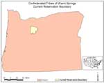
Current Reservation Boundaries, relative to the boundaries of the state of Oregon. Shows the addition of the McQuinn Survey of 1887, an area in the north encompassing 60,000 acres, federally recongized in 1972. (jpg)
Reservation Boundaries of 1855, relative to the boundaries of the state of Oregon. Over 10 million acres of land was ceded in the 1855 treaty, and the 640,000 acre reservation was created. (jpg)
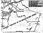
Traditional Territory of the Warm Springs and Wasco, showing the reservation boundaries and the location areas of many of the bands and key places in the "ceded" lands. (jpg)
Traditional Territory of the Pauite, showing the reservation boundaries. (jpg)
Key locations on the reservation, with the old reservation and new McQuinn boundaries marked out, ca. 1975. (jpg)
|
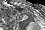
| View of the Celilo Falls area in 1922, before The Dalles Dam was built and flooded the falls, as a fly-over, three-dimensional image. Also view the falls at a 512k speed. (3-D "fly-over" simulation created from 1922 aerial photographs by Jim Crocker of the Confederated Tribes of Warm Springs GIS Program, 2002) |
Special thanks to Jim Crocker, Confederated Tribes of Warm Springs GIS Office, and Olivia Wallulatum, Legislative Coordinator of the Confederated Tribes of Warm Springs Office of Governmental Affairs, for the maps provided here.
© Confederated Tribes of Warm Springs 2003
| next >
|
|
|