| The aboriginal territory of the Nimíipuu, since time immemorial, is located in what is now called north-central Idaho, southeastern Washington, northeastern Oregon, and far western Montana, over 13 million acres in all. At the heart of the vast area are the Snake and Clearwater rivers, the northern reaches of the Salmon River basin, and Lake Wallowa. Bordering these great rivers are vast mountain ranges, the Bitterroots to the east, the Clearwater Mountains to the north, the Blues and Wallowas to the west, and the Salmon River Mountains to the south. This is the country within which the Corps of Discovery in 1805 encountered over 6,000 Nimíipuu successfully living their lives. This is the territory also adjudicated and reaffirmed in the Indian Claims Commission, a government commission of the 1960s established to clarify the reserved rights established by treaty, and to redress traditional lands taken without just compensation. See the ICC map
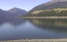 |
Wallowa Lake, Oregon
|
But these were not confining mountain ranges, as the Nimíipuu traveled extensively throughout and far beyond what is called the Plateau area. See the Traditional Use and Influence map. The Plateau is an area, which extends from the Cascade Mountains of Washington and British Columbia in the west to the Rocky Mountains of Montana in the east, encompassing the entirety of the Columbia River basin. The Fraser River valley of British Columbia marks the northern boundary, while the Columbia and Salmon Rivers of Oregon and Idaho mark the southern reaches of the Plateau.
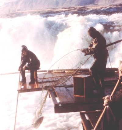 |
Fishing at Celilo Falls Photo courtesy the Nez Perce National Historical Park
|
Within the Plateau, the Nimíipuu share very close linguistic and cultural ties with the other Sahaptin speakers of Oregon and Washington, such as the Palouse, Walla Walla, Yakama, Umatilla, Wanapum of Priest Rapids, and Wayampam of Celilo Falls.
While smallpox epidemics, a series of treaties with the United States and other federal enactments, and the Conflict of 1877 greatly restricted access to and use of this aboriginal territory, today the over 3,300 Nimíipuu are reasserting their sovereign rights. On their reservation lands and throughout their "usual and accustomed use areas," ranging from Yellowstone National Park in Wyoming to the Hanford Nuclear Reservation along the Colombia River in Washington, Nimíipuu are active in the protection, preservation and perpetuation of their natural and cultural resources. In coordination with other state and federal governmental and tribal officials and biologists, the Nimíipuu are succussfully operating salmon and fish hatcheries and wolf recovery facilities in their "usual and accustomed lands."
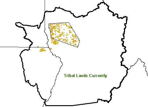 |
Current Tribal Lands Established in the Treaty of 1863, the 750,000 acre Nez Perce Reservation is located in north central Idaho (center of map), bordering southeastern Washington and northeastern Oregon to the west, with western Montana to the east. The outer line indicates the traditional homeland of the Nimíipuu, as acknowledged and reaffirmed in 1967 by the Indian Claims Commission (ICC) determination, totaling over 13 million acres. The yellow-shaded areas are lands actually owned by either the tribe or by tribal members, totaling about 185,000 acres.
|
© Nez Perce Tribe 2002
< previous |
next > |


