Some Important Prairie and Village Areas
from north to south
click to hear
Sq’apq’apine’ "sand" - Sandpoint area
Epsp’it’em "it has bitterroots" - Davenport area
Sq’wt’u - Cataldo area
Ni’laq’qn - "wide surface under the hair" - Wallace area
Hnch’mqinkwe' - "surface on the head of the water" - Coeur d’Alene city area
Q’emiln - "throat" - Post Falls area
Lo’lo’otm - "valley" - (a Spokane word) - Spokane Valley
Apl T’t’aq’‘n - "has a little saddle" - Worley area
Alkwari’t - "source of gold" (for the color of the lake waters at sunset) - Harrison area
Hnch’emtsn - "inner mouth" - St. Maries area
'L’lkhwi’lus - "little hole in the forehead" - DeSmet area
Ni’chichia’ra’lqw - "small cut in the woods" - Sanders area
Chatnna - "meadow" - Clarkia area
S’maqw’l - Moscow area
Palusiidi - "palouse" - (a Sahaptin-derived word) - Palouse area
chatqhesi'wes - "clear, open land" - prairie
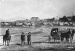 | | DeSmet, looking up at the mission. ca. 1909 |
|
|
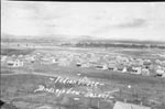 | | DeSmet, looking down from the mission. ca. 1920s |
The Schitsu’umsh were traditionally made up of three generally recognized groupings or "bands," each of which was associated with a particular winter village region. The first grouping, the Coeur d’Alene Lake band, was comprised of some sixteen villages made up of families located at sites on Hayden Lake, at the current cities of Coeur d’Alene and Post Falls, along the Spokane River near Green Acres, and on the shores of Liberty Lake. The second grouping, the Coeur d’Alene River band, comprised some eleven villages located along the Coeur d’Alene River, including sites situated near what would become the city of Harrison and the Cataldo Mission. The St. Joe River band made up the third grouping and was located in six villages along the lower St. Joe River and at the future site of St. Maries, with a single village located at the upper reaches of Hangman Creek.
|
|
Latah Creek Area - Listen as Felix Aripa explains the significance of the Latah Creek area and of the mammoth bones discovered there. The salmon used to come up this creek as far as the DeSmet area. This creek is also known as Hangman Creek. (recorded and edited by John Hartman on July 20, 2000 as part of the Coeur d'Alene Tribal GIS Names-Place Project) |
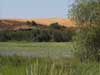
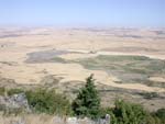 | | View from Steptoe Butte of the Prairie Lands | It may have been the case that there was an additional fourth Schitsu’umsh band, with those families living around Liberty Lake and along the Spokane River comprising a separate band, distinguished from those living at the north end of Lake Coeur d’Alene. In all instances, the larger of the winter villages often numbered some 300 individuals. Each of the three or four band were made up of interrelated families, who would typically winter in their band’s established area, though individual families might not winter in the same village from year-to-year. It was likely that the Spokane River and Liberty Lake families actually had more year-to-year contact with members of the Spokane tribe, located to the west and northwest, than they did with families located up the St. Joe River.
|
|
Elp'us'n - Lovell Valley Area - Listen as Felix Aripa relates the significance of the Lovell Valley area. (recorded by Paulette Jordaon and edited by John Hartman on July 20, 2000 as part of the Coeur d'Alene Tribal GIS Names-Place Project) |
© Coeur d'Alene Tribe 2002
< previous |
next >
|
|
|