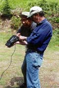
 | | Felix Aripa and John Hartman |
The Coeur d'Alene Tribe has been using Geographic Information System (GIS) to spatially depict their territories located in Idaho. For the past decade, GIS has served the Tribe in traditional functions of community and land management. Recently the Tribe's Elders became very excited about their GIS when it was proposed that it be used as a solution for preserving the Tribe's cultural heritage.
The Coeur d'Alene Tribe has had an active GIS program since 1992. A GIS is a computer system for capturing, storing, checking, integrating, manipulating, analyzing and displaying data related to positions on the Earth's surface. Typically, a GIS is used for handling various kinds of maps. These might be represented as several different layers in which each layer holds data about a particular kind of feature such as the location of cultural sites. Each
feature is linked to a position on the graphical image of a map. At this time, the Coeur d'Alene Tribe's GIS server contains over 3,000 GIS datasets. Currently, the Tribe employs five individuals in its GIS program whose talents include multimedia development, natural resource management, Internet applications development, and other computer related experience.
For years, the Tribal Elders asked the GIS project staff, "How can we say it's our land when our sites are labeled with the white man's words?" Moses Mountain, for instance, is known in the Coeur d'Alene language as Ch'ets'tene'st and translated "Log-like Rock Cliff" (click to hear; pronounced by Kim Matheson, recorded November 2002)
. In an effort to preserve the Tribe's language, the GIS team joined resources with the Tribe's linguist and began the GIS Names-Places Project in June 2000.
But labels alone do not give these locations cultural meaning; it is the Tribe's historical and ritual relationships to the land that creates connections. The Names-Places Project is a collaborative undertaking by the Coeur d'Alene Tribal Elders, the Language Center, and the GIS Program.
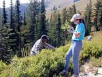 | | From Freezout Ridge |
The purpose of the Names-Places Project is to preserve Tribal culture
by visiting geographic sites and recording video, audio, and still
photos of Tribal Elders who describe the site in both English and
Coeur d'Alene languages. Locations of these sites are added to the
Tribal GIS. The GIS allows computer files to be linked to map sites
that are accessed with a simple mouse click. Database information in
the forms of digital video, audio, and still photos of the site are
interconnected with the map.
The goal of the Names-Places Project is to link geography, language,
and knowledge of the Coeur d'Alene Tribe aboriginal territory for the
preservation of Tribal Culture. Therefore, the Tribal Elders' knowledge of the aboriginal territory is priceless. Originally, the Tribe's aboriginal lands stretched south to the Clearwater River, Idaho, north to Sandpoint, Idaho, west to Spokane, Washington, and east to St. Regis, Montana spanning more than five million acres. The Tribe is aware of the need to complete this work before the knowledge slips away with the passing of the Elders. The Names-Places Project is working diligently to digitally record, preserve, and store this oral heritage.
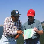 | | Felix Aripa and Raymond Brinkman | The culture of any people is embedded within their language. The growing concern for language revitalization is unquestionably valid. Because the Tribe's language expresses the thoughts of Tribal Ancestors' perceptions of the world, it is the key to understanding the inherent beauty of traditional ways. Thus, data may be preserved in both English and Coeur d'Alene languages.
Felix Aripa, one of the few people who still speak the Coeur d'Alene language, is a Tribal Elder at the heart of the Names-Places project. Even though Felix is in his eighties, he leads an entourage of specialists through the fields, forests, and mountains of the reservation on data gathering expeditions. Excited about such spatial tools as GPS for pinpointing important Tribal sites, Felix is enthusiastic about combining modern technology with Tribal tradition.
Seed money for the project was provided by the Tribe. Grants by Foundation Northwest and the National Park Service are funding continuation and refinements. So far, project participants have identified over one hundred and thirty geographic sites and have already visited fifty of them, inputting data entries in both English and Coeur d'Alene languages. In the first two years of the project, the team collected information that included thirtyfive hours of raw video, thirty hours of raw audio, and approximately fifteen hundred digital still photos. All raw information is captured in digital form and archived in its original recorded state. Edited video and audio clips will be attached to GIS maps for use in other computer presentations such as Power Point and websites.
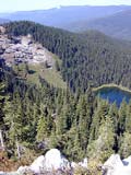 | | View of Crater Lake | Debate is ongoing regarding public access to all data because certain Tribal sites, such as burial grounds, are culturally sensitive information, which require Tribal protection. Therefore, the information continues to be preserved, but how this sensitive information will be distributed is still under consideration. The GIS format makes the Tribe's cultural history accessible to the next up and coming generations. Through interactive maps, a viewer can mouse click on a map site, which then drills in for closer inspection. Information drops down about the site offering perhaps up to three or four perspectives that might include a story told by an elder in both Coeur d'Alene and English, a history, as well as the site's videos and slides. Most Tribal GIS data will be served across the Tribal Intranet and placed on CD ROM for the planned local museum's kiosk.
© Coeur d'Alene Tribe 2002
< previous |
next >
|


