| Beginning in the 1850s America's Manifest Destiny confronted the Schitsu’umsh with an ever-increasing stream of white immigrants, either passing through or settling in their country. Many suyepmsh were lured by the hope of striking it rich from the gold deposits discovered in the nearby streams and mountains, and later hard-rock mining. Others saw the fertile soils of the region as promising farm land. In 1853 Washington Territory was established and its first governor, Isaac Stevens, in what has been characterized as a "rather heavy-handed" and "intimidating" manner, established a series of treaties with the area Tribes. It was the West Point-trained governor’s intension to confine as many Tribes as possible to rather limited reservations, thus opening up vast tracks of the land for white settlement. As a treaty was not at this time initiated with the Schitsu’umsh, the entire 5-million acre aboriginal territory of the tribe remained the sovereign domain of the Schitsu’umsh. In 1854 Stevens directed Capt. John Mullan to survey and begin construction of a 600-mile road linking Fort Benton on the Missouri with Fort Walla near the Columbia, running through the heart of Schitsu’umsh country. The consent of the tribe was not sought. With the steady stream of suyepmsh encroachment onto Indian lands, and the U.S. government unable or unwilling to control these unlawful trespasses, tensions steadily escalated.
|
Listen as Felix Aripa recounts how, with the coming of the white man, some of the elders didn't want to change, even preferring not to sleep on beds! (recorded by Rodney Frey, along the Clearwater River, August 2002.)
|
In May of 1858 Lieut. Col. Edward Steptoe, with some 150 troopers and 50 Nez Perce scouts, began a march from Fort Walla Walla to Colville country. But after crossing the Snake River, Steptoe took a very indirect route northeast into Palouse, Spokane and Schitsu’umsh territory. With his Nez Perce scouts taunting those they came upon that "we are going to help the soldiers take your lands," fighting soon broke out. Near the present town of Rosalia, Washington, Steptoe’s command found themselves outnumbered and surrounded by a combined force of some 500 Schitsu’umsh, Spokane, Palouse, Kalispel and Yakama warriors. Recognizing their hopeless situation, Chief Vincent, Andrew Seltice and Peter Wildshoe met with Father Joset and sent a message to Steptoe. If he agreed to leave his weapons behind and leave, they would provide safe passage out of Schitsu’umsh country. Steptoe agreed to the terms and under the cover of night and the drum beat of the Schitsu’umsh, the troops retreated to Fort Walla Walla. In all, 10 under Steptoe’s command were killed, while 9 Indians lost their lives in the conflict.
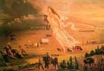
For the U.S. military, Steptoe’s "disaster" would not go unchecked. And in August of 1858, Col. George Wright led an aggressive campaign to punish and pacify the area Tribes. With well-equipped infantry and cavalry and new, long-range .58-caliber Springfield muskets and accurate howitzers, Wright’s troops defeated combined tribal forces of several hundred warriors at the battles of Four Lakes (near Medical Lake) and Spokane Prairie (just west of the city of Spokane). Following the defeats the Tribes sought peace. But as he moved toward Cataldo Mission, Wright pursued a "scorched-earth policy," indiscriminating slaughtering literally hundreds upon hundreds of horses and cattle, and burning barns and the food stored for the coming winter. Even those families who remained neutral during the conflict were "punished." Upon his return, Wright "lured" several Palouse and Yakama leaders to his camp and, without formal trial, hung these men. With ropes around their necks, the men deliberately jumped from the wagons, denying any pleasure to their executioners. One of those who died that day has descendants among a Schitsu’umsh family. Before he was killed and with family members gathered around, he passed along a song which is still cherished and sung to this day. The creek where this took place was subsequently renamed, Hangman Creek. And warriors could no longer protect their families from the onslaught of changes brought by the suyepmsh.
Spurred by the completion of the Mullan Road in 1862, the tide of squatters onto Schitsu’umsh lands continued to escalate. In 1866 alone, an estimated 20,000 people, 5,000 head of cattle and 6,000 mules traveled over the Mullan Road. With the hope of securing recognized borders and exclusive rights to the land within a reservation, head Chief Andrew Seltice and former head Chief Vincent, along with other headmen, reached an "agreement" with the U.S. government to create a reservation. Some 598,000 acres, including Lake Coeur d’Alene, were reserved for the "exclusive use of the Coeur d’Alene Indians." See map and Executive Order of 1873. In exchange for the over 4 million acres ceded to the United States, the Tribe was to receive a mill, blacksmith shop, school, farm implements, and $170,000. While congress did not approve the agreement, President Ulysses S. Grant, by executive order and as a temporary measure, established the Coeur d’Alene Reservation on November 8, 1873. But without congressional approval, the agreement could not provide remuneration for the ceded lands, nor confer "title" to the Tribe.
With the boundaries of the newly established reservation neither surveyed nor enforced by the federal government, the influx of settlers and miners, particularly in the northern regions of the reservation, continued unabated. In August of 1889 another Indian Commission began meeting with the Schitsu’umsh and an agreement was reached in which the northern section of the reservation would be ceded in exchange for $500,000, to be divided among the remaining 500 Schitsu’umsh (given the ravages of smallpox). See map. A reservation of some 400,000 acres was established. The agreement stated (in Article 5) that no part of the resulting reservation shall be sold or occupied by whites without the consent of the Schitsu’umsh. And with the 1889 session the traditional head village of Hnch’mqinkwe’ ("Surface of the Head of the Water") would become the site of the rapidly growing city of Coeur d’Alene. On March 3, 1891 Congress ratified the Agreement of 1889, (which includes the Agreement of 1887, signed by the headmen of the Tribe but never ratified by Congress). See Executive Order of 1889.
Nevertheless, settlers continued to ignore the reservation borders, especially at the mouth of the Coeur d’Alene River, naming their community after the current president, Harrison. Instead of removing the squatters, the government in 1894 removed the land from the Schitsu’umsh in exchange for $15,000 and another traditional village, Alkwari’t ("Source of Gold," referring to the shine on the lake’s water at sunset), was lost to the suyepmsh. See map. Today the Coeur d'Alene Reservation boundaries encompass some 345,000 acres of land.
© Coeur d'Alene Tribe 2002
< previous |
next >
|