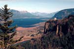
 | | The Columbia Gorge, ca. 1988. |
The idea of a tribe’s or even a family’s territory differs
from that of Euro-American society. Traditionally, neither a family, nor an individual, and certainly not a tribe would say they “owned” a territory, having exclusive right to it to do with it as they pleased. All were free to travel the trails and over the waters associated with particular villages. Out of respect, however, small tokens and gifts might be left as one passed by such villages. Nevertheless, individual families that seasonally used established fishing sites did have the sole right to fish there. So long as the family continued to use and care for that fishing site, it would remain with that family and others would not seek access to it without their permission. This is not to suggest that tribes, bands and families were freely roaming the country side, altering their locations from generation-to-generations. There were established territories for the Warm Springs, Wasco and Paiute families, constituted since time immemorial.
|
|
Garland Brunoe talks about why the Creator placed the Indian people along the Columbia River and the special responsibilities the people have as stewards of the land. (Interviewed by Brigette Whipple, October 2003) |
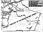
The Chinookan-speaking Wasco bands traditionally lived along the southern banks of the Columbia River, with permanent year-round villages from the Great Narrows and Fivemile Rapids (just above The Dalles and below Celilo Falls) down river to east of where the Hood River enters the Columbia. See map. Our bands were named the People of the Narrows, the Dog River, and the Ki-gal-twal-la. The closely-related Wishram bands lived across the river, along the north bank of the Columbia. We had many villages along the length of the Columbia River, with two located near where the city of The Dalles now stands, and the other just below Fivemile Rapids, east of the city of The Dalles. The tribal designation, "Wasco," is derived from the village of Wa'sqo (Was'sqlo), located just below the Great Narrows.
|
|
Jacob Frank considers the location of many of the Warm Springs bands at the time of the signing of the Treaty of 1855. (Interviewed by F. Duran Bobb and Tim Finch, December 2002) |
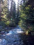 | | Warm Springs River, in the Mountains |
The ancestral bands of the Sahaptin-speaking Warm Springs inhabited the area along the southern bank of the Columbia River, roughly between the John Day River, down river to Fivemile Rapids. See map. Among these bands were the Teninos, who lived at Tenmile Rapids, the Wyams, who resided at Celilo Falls, the Tuks’push (Dock Spus) band lived along the upper reaches of the John Day River, and the Ty-gh band, who were located along the upper Deschutes River. Collectively, these bands became known in the language of the treaty-writers as, "Walla Walla," but we perfer to call ourselves, Warm Springs. In addition to canoe travel over the rivers, well-travel overland trails connected these bands with one another. Relations with their neighboring Wasco were typically peaceful.
|
|
Emily Waheneka discusses the names of the people along the Columbia River. (Interviewed by Brigette Whipple. October 2002) |
The aboriginal territories of the Warm Springs and Wasco tribes thus extended from the slopes of the Cascades in the west to the Blue Mountains in the east, and from the Columbia River to as far south as the present city of Bend, Oregon. Upon being relocated to the reservation in the 1850s, many of the Warm Springs families settled in the Simnasho community, while the Wasco families settled in what would become the Warm Springs community, where the BIA Agency Offices were located.
The Shoshoean-speaking Northern Paiute families traditionally lived in a vast region well south of the Columbia River, throughout the high plateau country of the Great Basin, from southeastern Oregon into Nevada, Idaho and western Utah. Some Paiute familes had even seasonally-traveled to the upper reaches of the John Day, Crooked, and Deschutes rivers to gather their foods. The Paiute bands that eventually settled on the Warm Springs Reservation had lived in the area of Lake, Harney, and Malheur counties in Oregon. See map. Referred to as the “Snakes” by Meriwether Lewis and William Clark in 1805, the Northern Paiute bands were often skirmishing with their northerly neighbors, the Wasco and Warm Springs bands. In 1879, some Paiute captives were released from Fort Vancouver and relocated to the Warm Springs Reseration. And in 1882, other Paiutes, held on the Yakama Reservation, joined those released three years earlier on the Warm Springs Reservation. See Concessions. Many of these Paiute families still live in the community of Seekseekqua, located in the southern part of the reservation.
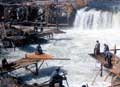
 | | Celilo Fishing Site. |
The Treaty with the Tribes of the Middle Oregon 1855 removed the Wasco and Warm Springs bands from their Columbia River homes to a reservation some 90 miles to the south, along the Deschutes River. The tribes ceded over 10 million acres to the United States, in exchange for the 640,000 acres creating the Warm Springs Reservation. The four Sahaptin-speaking bands were relocated to the Simnasho area. The Wasco bands were relocated to the center of the reservation, near the BIA agency of Warm Springs. In 1879 and 1882, some Paiute families were moved to the Warm Springs Reservation and settled in the southern region.
|
|
Harrison Davis Sr. talks about his first experiences at Celilo Falls, of being taught how to fish from Chief Tommy Thompson, and what the dip nets were made from. (Interviewed by Brigette Whipple, January 2003)
|
Some families refused to move to the reservation, staying at Celilo Village (joined by many Yakama families) and other traditional fishing sites along the Columbia River. Today, while located off the reservation, many of these small land holdings are on federally-recognized trust lands reserved to tribal use and are the residence of a few families. See Usual and Accustomed for a brief discussion of trust status. In 1980 the Confederated Tribes of Warm Springs purchased the area around Sherar's Falls, along the Deschutes River, thus bringing this important traditional fishing site under tribal control again.
© Confederated Tribes of Warm Springs 2003
< previous |
|