Louisiana Territory
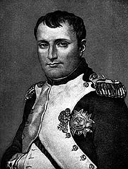 |
| Napoleon decided to sell the Louisiana Territory to the United States to concentrate on Franceâs military efforts at home. Image © 2002 www.clipart.com. |
Napoleon Reacquires Louisiana!
American Merchants Denied Access to New Orleans Port!
War Looms Over Louisiana!
For Americans the hot geopolitical question of early 1803 was political control of the port of New Orleans at the mouth of the Mississippi River. Napoleon, the new master of Europe, had taken New Orleans and the Louisiana Territory back from the Spanish in order to establish a new French empire in the New World. Louisiana—which included all of the Mississippi and Missouri River valleys—was envisioned to become the center of food production for the new empire. But Louisiana Territory and New Orleans were vital to the Americans as well. By 1800 40 percent of America's commerce already flowed down the Mississippi through New Orleans. Further, the Louisiana Territory lay directly across the path of American expansion. Indeed, American pioneers were already moving into the region. Economic crisis loomed, manifest destiny beckoned, and the threat of war filled the air.
Disaster was averted when military reverses in the slave revolt in the French colony of Santo Domingo convinced Napoleon that it would be too difficult and expensive to hold onto his new American empire. Cutting his losses, Napoleon sold Louisiana to the United States in early 1803 for $15 million.
But what had America bought? The lands up the Missouri River valley and across the Rocky Mountains to the Pacific Coast were terra incognita—unknown territory. Explorers had probed the edges of the area, but the interior of the region had not yet been penetrated by white men. Many cartographers drew maps of North America, but the unknown lands were not left blank. Instead, they were filled with features that ranged from the reasonable to the ridiculous: rivers, giant volcanoes, a mountain of rock salt, fabulous animals like mastodons, and advanced Indian civilizations living in great wealth and splendor around giant lakes.
Thomas Jefferson, one of the foremost students in the world of American geography, eagerly gathered all of the documents and maps he could find of the unexplored Northwest. The Lewis and Clark expedition was born of Jefferson's desire to find an all-water route to the Pacific and to discover the potential of the unknown lands for American settlement. What they expected to find was based on guesses and geographical theories extrapolated from hearsay and the meager knowledge available.
next > | 


