HOME
Monticello
Maps
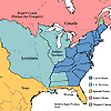
North America Political Boundries in 1803
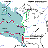
French Explorations of the Louisiana Territory, 1672-1743
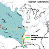
Spanish Explorations of the Louisiana Territory, 1720-1793
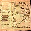
A 1735 Map Showing the Missouri River on a Straight Course West
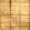
Nicolas de Finiels’ Map of Missouri River, 1798
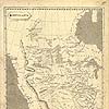
Samuel Lewis’ Map of Northwestern North America, 1804
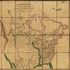
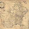
Arrowsmith’s 1802 Map of North America
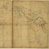
King’s 1803 Map of North America
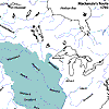
Mackenzie Route from Fort Chipewyan to the Pacific Ocean, 1793
Jonathan Carver’s Map of North America, 1778
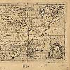
Map of Louisiana by du Pratz, 1757
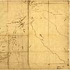
Thomson’s Map of the Big Bend, 1798
Maps for Monticello
Maps of Philadelphia
North American Political Boundaries in 1803
French Explorations of the Louisiana Territory, 1672-1743
Spanish Explorations of the Louisiana Territory, 1720-1793
A 1735 Map Showing the Missouri River on a Straight Course West
Arrowsmith’s 1802 Map of North America
King’s 1803 Map of North America
Mackenzie Route from Fort Chipewyan to the Pacific Ocean, 1793
Nicolas de Finiels’ Map of Missouri River, 1798
Samuel Lewis’ Map of Northwestern North America, 1804
Jonathan Carver’s Map of North America, 1778
Map of Louisiana by du Pratz, 1757
Thomson’s Map of the Big Bend, 1798