|
|
|
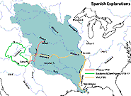
Spanish Explorations of the Louisiana Territory, 1720-1793
 Spanish Explorations of the Louisiana Territory, 1720-1793 Spanish Explorations of the Louisiana Territory, 1720-1793
This map displays Spanish explorations of the Louisiana Territory, including Escalante’s expedition that was motivated by the desire to link the Spanish colonies in New Mexico and California. The Spanish extension of the French exploration yielded a more realistic view of the Louisiana Territory landscape. |
|
|


