HOME
click here to return to the main page
Monticello
Expedition Culture Geography People Maps Nature
Maps
  North America Political Boundries in 1803
French Explorations of the Louisiana Territory, 1672-1743
Spanish Explorations of the Louisiana Territory, 1720-1793
A 1735 Map Showing the Missouri River on a Straight Course West
Nicolas de Finiels’ Map of Missouri River, 1798
Samuel Lewis’ Map of Northwestern North America, 1804
Arrowsmith’s 1802 Map of North America
King’s 1803 Map of North America
Mackenzie Route from Fort Chipewyan to the Pacific Ocean, 1793
Jonathan Carver’s Map of North America, 1778
Map of Louisiana by du Pratz, 1757
Thomson’s Map of the Big Bend, 1798

Mackenzie Route from Fort Chipewyan to the Pacific Ocean, 1793

Mackenzie Route from Fort Chipewyan to the Pacific Ocean, 1793
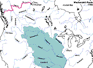
In 1793 Alexander Mackenzie followed the Peace River upstream to its source. There he found a 700-meter portage over a poorly defined ridge to the headwaters of a different river system flowing west toward the Pacific.