|
|
|
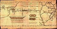
A 1735 Map Showing the Missouri River on a Straight Course West
 A 1735 Map Showing the Missouri River on a Straight Course West A 1735 Map Showing the Missouri River on a Straight Course West
This 1735 map is an example of how early maps speculatively represented the western territories of North America. In this map the Missouri River is shown as a straight watercourse flowing into a large lake in the distant west. Just west of the lake the map shows a single ridge of mountains flanked by streams and a large river flowing toward the Pacific Ocean. Map courtesy of the Library of Congress. |
|
|


