|
|
|
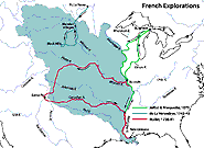
French Explorations of the Louisiana Territory, 1672-1743
 French Explorations of the Louisiana Territory, 1672-1743 French Explorations of the Louisiana Territory, 1672-1743
This map displays French explorations of the Louisiana Territory, 1672-1743. During the 1600s French explorers came down the St. Lawrence River, through the Great Lakes, and down the Mississippi River to the Gulf of Mexico. The French founded New Orleans, the vital port at the mouth of the Mississippi River, in 1718. |
|
|


