HOME
click here to return to the main page
Monticello
Expedition Culture Geography People Maps Nature
Maps
  North America Political Boundries in 1803
French Explorations of the Louisiana Territory, 1672-1743
Spanish Explorations of the Louisiana Territory, 1720-1793
A 1735 Map Showing the Missouri River on a Straight Course West
Nicolas de Finiels’ Map of Missouri River, 1798
Samuel Lewis’ Map of Northwestern North America, 1804
Arrowsmith’s 1802 Map of North America
King’s 1803 Map of North America
Mackenzie Route from Fort Chipewyan to the Pacific Ocean, 1793
Jonathan Carver’s Map of North America, 1778
Map of Louisiana by du Pratz, 1757
Thomson’s Map of the Big Bend, 1798

Arrowsmith’s 1802 Map of North America

Arrowsmith’s 1802 Map of North America
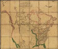
The large blank areas on Arrowsmith’s 1802 map of North America show how little was known about the lands up the Missouri River Valley and across the Rocky Mountains. Explorers had probed the edges of the region, but Europeans had not yet penetrated the interior. Map courtesy of the Library of Congress.

View also in MrSID format.