|
|
|
| Nicolas de Finiels’ Map of Missouri River, 1798
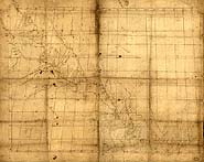 Nicolas de Finiels’ 1798 map details the Missouri River from St. Charles in the lower right corner of the map to the Mandan Villages in the upper left. Map courtesy of the Library of Congress. Nicolas de Finiels’ 1798 map details the Missouri River from St. Charles in the lower right corner of the map to the Mandan Villages in the upper left. Map courtesy of the Library of Congress.
View in MrSID format.
|
|
|


