|
|
|
| Thomson's Map of the Big Bend, 1798
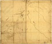 Thomson's 1798 map of the Big Bend area of the Missouri River illustrates the location of the Mandan Villages near the confluence of the Knife and Missouri rivers. Map courtesy of the Library of Congress. Thomson's 1798 map of the Big Bend area of the Missouri River illustrates the location of the Mandan Villages near the confluence of the Knife and Missouri rivers. Map courtesy of the Library of Congress.
View in MrSID format.
|
|
|


