| Samuel Lewis’ Map of Northwestern North America, 1804
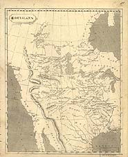 Like most maps of this era, Samuel Lewis' 1804 map of northwestern North America shows a single ridge of Rocky Mountains. Cartographers used mountain chains like the Appalachians back east as their influence. They couldn’t envision the broad spread of the Rockies. Map courtesy of the Library of Congress. Like most maps of this era, Samuel Lewis' 1804 map of northwestern North America shows a single ridge of Rocky Mountains. Cartographers used mountain chains like the Appalachians back east as their influence. They couldn’t envision the broad spread of the Rockies. Map courtesy of the Library of Congress.
View in MrSID format.
|


