Links
To continue the discussion on the aboriginal lands, consider visiting:
Ancestor Lands, on the Coeur d'Alene Tribe's home page.
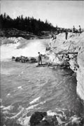 | | Fishing at Kettle Falls, ca. 1930s |
|
|
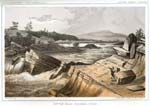 | | Kettle Falls, ca. 1853 |
The aboriginal landscape of the Schitsu’umsh encompassed much of what would become the Panhandle region of Idaho, extending into parts of eastern Washington and western Montana. See Aboriginal Territory map. Lake Pend Oreille marked the northern boundary, with the country beyond the home of the Kalispel and Pend Oreille peoples. With mountain passes up to 5,200 feet in elevation, the Bitterroot Range of Montana marked the easterly area of Schitsu’umsh. The Flathead people made their home on the other side of these mountains. The Palouse River over to the North Fork of the Clearwater River and the Clearwater Mountains established the southern boundary, with the Nez Perce on the other side of these mountains. Just east of Spokane Falls along the Spokane River, then extending south along the Hangman (Latah) and Pine Creek drainages to Steptoe Butte marked the western reaches of the Schitsu’umsh landscape. The Spokane people lived to the northwest and west, while the Palouse Indians inhabited the area to the southwest. At the heart of this vast landscape is Lake Coeur d'Alene, "home" for the Schitsu'umsh. Its waters sprang from slopes of the Bitterroot and Clearwater Mountains, gathered into the Coeur d'Alene and St. Joe rivers, fed into the lake itself, and then drained into the Spokane and eventually Columbia rivers. It was a landscape of nearly 5,000,000 acres of fir, ponderosa and cedar-forested mountains, as well as freshwater rivers, lakes, marshlands, and white pine, perennial bunchgrass and fescue wheatgrass-covered rolling hills and prairies.
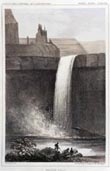 | | Palouse Falls, ca. 1853 |
While these were boundaries recognized by neighbors and the Schitsu’umsh, they were fluid outlines rather than confining enclosures. Schitsu’umsh families seasonally traveled well into the country far to the west of Hangman Creek to dig bitterroot, met with other Salish peoples at Kettle Falls on the Columbia to the northwest to fish and trade, gathered huckleberries with the Kalispel in the berry patches around Lake Pend Oreille to the north, and, after the arrival of the horse and accompanied by Spokane and Flathead families, traveled east into what would become Montana to hunt buffalo. Some families continue to pick huckleberries on the mountains surrounding Lake Pend Oreille and assemble at Spokane Falls with other regional tribes to share in song and dance, and renew kinship.
© Coeur d'Alene Tribe 2002
< previous
| next >
|
|
|


