International Relations
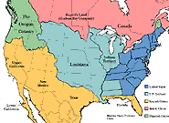 |
| This map of North America shows political boundaries in 1803 after Napoleon sold Louisiana to the United States for $15 million. |
The lands of the West were a hot commodity not just to America, but to other countries as well. In that time of exploration and expansion, for example, Spanish conquistadors had ventured toward the Southwest region of the United States, while both French and Spanish fur traders traveled near the Missouri River. The British had even visited the Mandan Indians near present-day South Dakota and developed fur trading interests in Upper Louisiana while the Russians were interested in the area around the Columbia River.
In concrete terms Spain had territorial claim of the West and South of the United States, while Great Britain claimed Canada—the area north of the United States. In 1803, however, the young country acquired a valuable stretch of land as well called the Louisiana Territory. Covering approximately 828,000 miles from the Mississippi River to the Rocky Mountains, this purchase nearly doubled the size of the United States and connected it with Oregon Country—land to which Spain, Russia, France, and Britain all had overlapping claims.
Oregon Country extended along the Pacific coast of North America from the northern boundary of Spanish-owned California to the southern boundary of what was then called "Russian America" and is now Alaska. Oregon Country generally covered present-day Washington, Oregon, Idaho, and a small section of Montana. The Louisiana Territory itself included the 15 present-day states of Montana, Wyoming, North Dakota, South Dakota, Colorado, Nebraska, Kansas, Minnesota, Iowa, Missouri, New Mexico, Texas, Oklahoma, Arkansas, and Louisiana.
< back | next > |


